
- Maps And Pho…
- Imagery
- UAV Imagery And Services
UAVs offer an extremely flexible and accurate solution for capturing data.
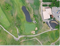
ISC is pleased to offer high resolution UAV (Unmanned Aerial Vehicles) imagery. If your project requires imagery at a higher resolution or more current than satellite imagery offers this drone technology may be best for your project.
UAVs offer an extremely flexible and accurate solution for capturing data. If you need information that is current, accurate, or requires a high level of detail, then this is the perfect technology for you.
Our drone data collection service is based on our customers with solutions tailored to your needs. We manage all legal requirements, safety considerations, flight operations and data processing to ensure that you have the information you need, when you need it.