
- Maps And Pho…
- Imagery
- Sgic Ortho Imagery
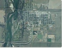
Beginning in 2008, the Saskatchewan Geospatial Imagery Collaborative (SGIC) is acquiring current, high-resolution imagery of Saskatchewan for mutual and public benefit. ISC is the official distributor of this exciting new imagery and related value-add services. Product Sample
The Saskatchewan Geospatial Imagery Collaborative (SGIC) is a partnership of organizations within Saskatchewan sharing knowledge and costs relating to the acquisition and use of remotely sensed imagery for mutual and public benefit. SGIC Imagery is designed to serve as a common base for a range of applications including zoning, land use, assessment, planning and any application which requires current, high-resolution imagery of land in Saskatchewan. ISC, a member of SGIC, provides value-add services to enable customers to derive value from the use of the imagery and effectively make use of it for integration into their systems, for decision-making, display or other purposes.
SGIC-2 Ortho Imagery
ISC now offers SGIC-2 ortho imagery for select locations in Saskatchewan. For pricing and product location availability please contact 1-866-ASK-ISC1 (1-866-275-4721) or [email protected].**See the 'SGIC-2 Ortho Photo Imagery - Currently Available' map for current coverage.**
Product Specifications
| Type: | Digital Aerial Ortho-rectified Photography and Auxiliary Data |
| Positional Accuracy: | 3 metres (horizontal), 3 metres (vertical) |
| Spectrum: | Colour, Colour Infrared |
| Pixel Resolution: | 0.6 metre |
| Format: | Imagery in GeoTIFF, TIFF and JPG format Digital Elevation Model (DEM) in USGS format Mass points & break lines in ESRI ArcShape (SHP) format |
| Projection: | UTM Zone 13 |
| Datum: | NAD83, CSRS98 |
| End-user License: | Yes (for digital data) |
| Coverage: | 20% of province per year beginning in 2008 |
Pricing Information*
Digital
| Digital TIFF Township or Section: | $52.00 per Township or Section |
| Digital JPG Section: | $28.00 per Section |
| Digital GeoTIFF Township or Section: | $52.00 per Section $105.00 per Township |
| Digital Elevation Model (DEM) in USGS format | $52.00 per Township or Section |
* Discounts may apply for large volume requests.
Hardcopy
| Hardcopy Township Photomap: | $21.00 per Township |
Historic Orthophoto/Digital Elevation Model Products
Contact us for more information.
Custom Products
We offer custom services where we can overlay various datasets on top of SGIC Ortho Imagery to enable you to derive maximum value from the imagery for navigational, decision-making, display or other purposes. For more information or to view samples now, check out Custom Mapping and GIS Services.
Order Now
To order this product now, please contact us by one of the options below.| Phone (Toll Free): | 1-866-ASK-ISC1 (1-866-275-4721) |
| Email: | [email protected] |
| Payment Information: | All orders must be paid for at the time the order is placed, or can be charged against your GDC account (if you have one). |
| We accept MasterCard, VISA, cash, debit or cheque. (Cash and cheque, Canadian funds only.) |